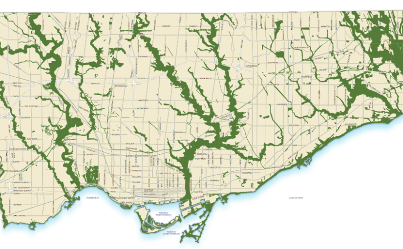
“The city within a park” – Toronto’s astounding network of ravines is among the largest in the world. It is a network of deep ravines that form a large urban forest that runs throughout much of the city.

The largest ravines are home to the rivers running south to the shores of Lake Ontario from the Oak Ridges moraine: the Humber River, the Don River, and the Rouge River, carrying water, wildlife and people through Ontario’s most densely urbanized area.

There are four major groups of ravines, and many smaller groups scattered throughout the city. The Humber River is in the west. The Don River empties into Lake Ontario just to the east of downtown. Highland Creek flows into Lake Ontario at the eastern edge of the Scarborough Bluffs. At the far east of the city of Toronto is the Rouge River system. The Rouge became Canada’s first urban national park in June 2017.

Once seen as the biggest challenge to Toronto’s growth, these corridors of “disordered nature” are now treasured as one of its greatest assets. Rich in natural character and biodiversity, they provide many ecological benefits and are for many a cherished escape from the fast pace of urban life. A number of the ravines now have paved paths, well maintained bridges, and stairs. Citizens can walk for miles across the city through these trails.

While located in the heart of one of North America’s largest cities, most of the ravines are deserted most of the time. Certain parts of the ravines are known as gay cruising areas.